SHIP BOTTOM, N.J. - Forget distinctions like tropical storm or hurricane. Don't get fixated on a particular track. Wherever it hits, the rare behemoth storm inexorably gathering in the eastern U.S. will afflict a third of the country with sheets of rain, high winds and heavy snow, say officials who warned millions in coastal areas to get out of the way.
"We're looking at impact of greater than 50 to 60 million people," said Louis Uccellini, head of environmental prediction for the National Oceanic and Atmospheric Administration.
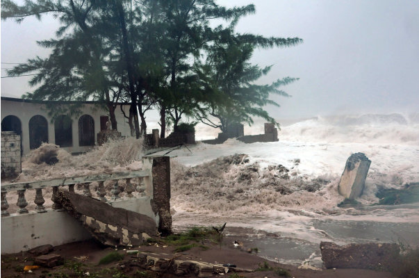
As Hurricane Sandy barrelled north from the Caribbean — where it left nearly five dozen dead — to meet two other powerful winter storms, experts said it didn't matter how strong the storm was when it hit land: The rare hybrid storm that follows will cause havoc over 800 miles from the East Coast to the Great Lakes.
"This is not a coastal threat alone," said Craig Fugate, director of the Federal Emergency Management Agency. "This is a very large area."
President Barack Obama was monitoring the storm and working with state and locals governments to make sure they get the resources needed to prepare, administration officials said.
New Jersey Gov. Chris Christie declared a state of emergency Saturday as hundreds of coastal residents started moving inland and the state was set to close its casinos.
New York's governor was considering shutting down the subways to avoid flooding and half a dozen states warned residents to prepare for several days of lost power.
Sandy weakened briefly to a tropical storm Saturday but was soon back up to Category 1 strength, packing 75 mph winds. It was about 275 miles south-southeast of Cape Hatteras, N.C., and moving northeast at 14 mph as of 2 a.m. Sunday. Forecasters said the storm was spreading tropical stormconditions across the coastline of North Carolina, and they were expected to move up the mid-Atlantic coastline late Sunday. Experts said the storm was most likely to hit the southern New Jersey coastline by late Monday or early Tuesday.
Governors from North Carolina, where heavy rain was expected Sunday, to Connecticut declared states of emergency. Delaware ordered mandatory evacuations for coastal communities by 8 p.m. Sunday.
Christie, who was widely criticized for not interrupting a family vacation in Florida while a snowstorm pummeled the state in 2010, broke off campaigning for Republican presidential nominee Mitt Romney in North Carolina on Friday to return home.
"I can be as cynical as anyone," Christie said in a bit of understatement Saturday. "But when the storm comes, if it's as bad as they're predicting, you're going to wish you weren't as cynical as you otherwise might have been."
The storm forced the presidential campaign to juggle schedules. Romney scrapped plans to campaign Sunday in the swing state of Virginia and switched his schedule for the day to Ohio. First lady Michelle Obama cancelled an appearance in New Hampshire for Tuesday, and Obama moved a planned Monday departure for Florida to Sunday night to beat the storm. He cancelled appearances in Northern Virginia on Monday and Colorado on Tuesday.
In Ship Bottom, just north of Atlantic City, Alice and Giovanni Stockton-Rossini spent Saturday packing clothing in the backyard of their home, a few hundred yards from the ocean on Long Beach Island. Their neighbourhood was under a voluntary evacuation order, but they didn't need to be forced.
"It's really frightening," Alice Stockton-Rossi said. "But you know how many times they tell you, 'This is it, it's really coming and it's really the big one' and then it turns out not to be? I'm afraid people will tune it out because of all the false alarms before ... (but) this one might be the one."
A few blocks away, Russ Linke was taking no chances. He and his wife secured the patio furniture, packed the bicycles into the pickup truck, and headed off the island.
What makes the storm so dangerous and unusual is that it is coming at the tail end of hurricane season and the beginning of winter storm season, "so it's kind of taking something from both," said Jeff Masters, director of the private service Weather Underground.
Masters said the storm could be bigger than the worst East Coast storm on record — the 1938 New England hurricane known as the Long Island Express, which killed nearly 800 people. "Part hurricane, part nor'easter — all trouble," he said. Experts said to expect high winds over 800 miles and up to 2 feet of snow as far inland as West Virginia.
And the storm was so big, and the convergence of the three storms so rare, that "we just can't pinpoint who is going to get the worst of it," said Rick Knabb, director of the National Hurricane Center in Miami.
Officials are particularly worried about the possibility of subway flooding in New York City, said Uccellini.
New York Gov. Andrew Cuomo told the Metropolitan Transportation Authority to prepare to shut the city's subways, buses and suburban trains by Sunday, but delayed making a final decision. The city shut the subways down before last year's Hurricane Irene, and a Columbia University study predicted that an Irene surge just 1 foot higher would have paralyzed lower Manhattan.
Up and down the Eastern Seaboard and far inland, officials urged residents and businesses to prepare in big ways and little.
On Saturday evening, Amtrak began cancelling train service to parts of the East Coast, including between Washington, D.C., and New York. Airlines started moving planes out of East Coast airports to avoid damage and adding flights out of New York and Washington on Sunday in preparation for flight cancellations on Monday.
The Virginia National Guard was authorized to call up to 500 troops to active duty for debris removal and road-clearing, while homeowners stacked sandbags at their front doors in coastal towns. At a Home Depot in Virginia Beach, employee Dave Jusino said the store was swamped with customers.
"We have organized chaos, is what I call it," Jusino said. "We organize a group of 10 associates, give them certain responsibilities and we just separate the lines, organize four customers at a time, load up their cars and get them out the door and then take the next customers."
Utility officials warned rains could saturate the ground, causing trees to topple into power lines, and told residents to prepare for several days at home without power. "We're facing a very real possibility of widespread, prolonged power outages," said Ruth Miller, spokeswoman for the Pennsylvania Emergency Management Agency.
Warren Ellis, who was on an annual fishing pilgrimage on North Carolina's Outer Banks, didn't act fast enough to get home. Ellis' 73-year-old father managed to get off uninhabited Portsmouth Island near Cape Hatteras by ferry Friday. But the son and his camper got stranded when high winds and surf forced the ferry service to suspend operations Saturday.
"We might not get off here until Tuesday or Wednesday, which doesn't hurt my feelings that much," said Ellis, 44, of Amissville, Va. "Because the fishing's going to be really good after this storm."
Last year, Hurricane Irene poked a new inlet through the island, cutting the only road off Hatteras Island for about 4,000.
In Connecticut, the Naval Submarine Base in Groton prepared to install flood gates and pile up sandbags to protect against flooding while its five submarines remain in port through the storm.
Lobsterman Greg Griffen in Maine wasn't taking any chances; he moved 100 of his traps to deep water, where they are less vulnerable to shifting and damage in a storm.
"Some of my competitors have been pulling their traps and taking them right home," said Griffen. The dire forecast "sort of encouraged them to pull the plug on the season."
In Muncy Valley in northern Pennsylvania, Rich Fry learned his lesson from last year, when Tropical Storm Lee inundated his Katie's Country Store.
In between helping customers picking up necessities Saturday, Fry was moving materials above the flood line. Fry said he was still trying to recover from the losses of last year's storm, when he estimates he lost $35,000 in merchandise.
"It will take a lot of years to cover that," he said.
Christie's emergency declaration will force the shutdown of Atlantic City's 12 casinos for only the fourth time in the 34-year history of legalized gambling here. The approach of Hurricane Irene shut down the casinos for three days last August.
Atlantic City officials said they would begin evacuating the gambling hub's 30,000 residents at noon Sunday, busing them to mainland shelters and schools.
Tom Foley, Atlantic City's emergency management director, recalled the March 1962 storm when the ocean and the bay met in the centre of the city.
"This is predicted to get that bad," he said.
Eighty-five-year-old former sailor Ray Leonard said if he had loved ones living in the projected landfall area, he would tell them to leave. Leonard knows to heed the warnings.
He and two crewmates in his 32-foot sailboat, Satori, rode out 1991's infamous "perfect storm," made famous by the Sebastian Junger bestseller of the same name, before being plucked from the Atlantic off Martha's Vineyard, Mass., by a Coast Guard helicopter.
"Don't be rash," Leonard said in a telephone interview Saturday from his home in Fort Myers, Fla. "Because if this does hit, you're going to lose all those little things you've spent the last 20 years feeling good about."
___
Breed reported from Raleigh, N.C. Contributing to this report were AP Science Writer Seth Borenstein in Washington; Emery Dalesio in Kill Devil Hills, N.C.; Karen Matthews and Samantha Bomkamp in New York; Glenn Adams in Augusta, Maine; Randall Chase in Lewes, Del.; Rodrique Ngowi in Boston; Ron Todt in Philadelphia and Nancy Benac in Washington.
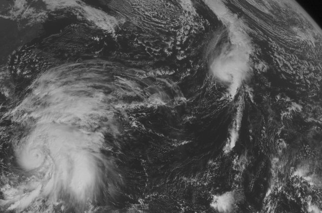 Associated Press - This NOAA satellite image taken Wednesday, October 24, 2012 at 1:45 PM EDT shows Hurricane Sandy across the central Caribbean moving northward toward Jamaica and Cuba. Tropical Storm Tony



No comments:
Post a Comment
Note: Only a member of this blog may post a comment.